

ne sledite
Napaka pri sledenju uporabnika.
Ta uporabnik drugim uporabnikom ne dovoli, da mu sledijo.
Temu uporabniku že sledite.
Vaš paket članstva omogoča samo 0 sledenj. Nadgradite tukaj.
Sledenje je bilo uspešno preklicano
Napaka pri preklicu sledenja uporabnika.
Uspešno ste priporočili
Napaka pri priporočanju uporabnika.
Nekaj je šlo narobe. Osvežite stran in poskusite znova.
E-naslov uspešno verificiran.

lahore,
pakistan
Trenutno je 8:34 pop. tukaj
Datum pridružitve julij 13, 2017
0 Priporočila
Muneeb A.
@MUNEEBAAMIR
0,0
0,0
0%
0%
lahore,
pakistan
Ni relevantno
Opravljeno delo
Ni relevantno
V okviru proračuna
Ni relevantno
Pravočasno
Ni relevantno
Stopnja ponovnega najema
Geospatial Expert
Stopite v stik s/z Muneeb A. glede vašega dela
Prijavite se, da se o podrobnostih pogovorite v klepetu.
Portfelj
Portfelj


Preparation of Digital Elevation Model
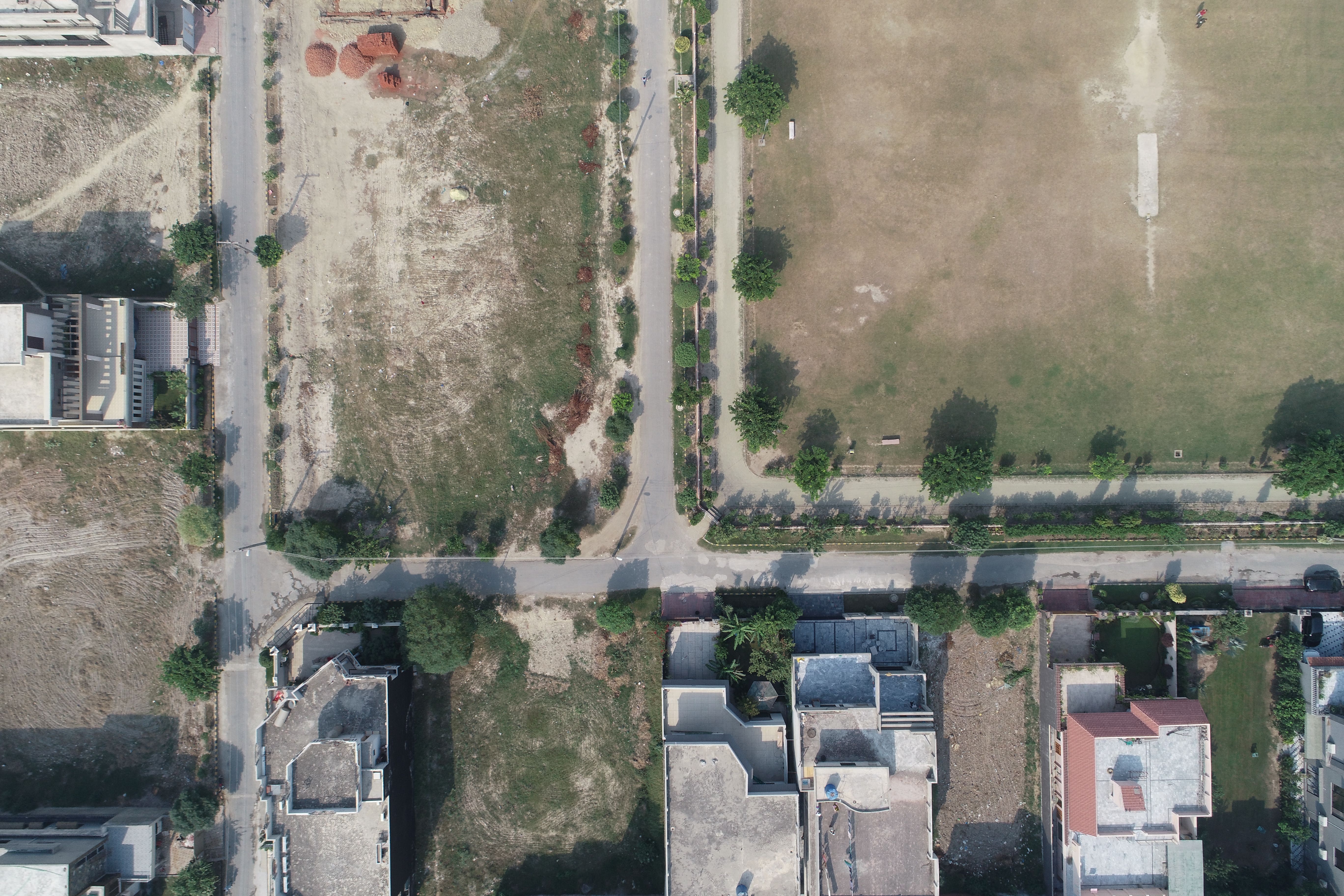

Drone Mapping

Drone Mapping

Drone Mapping
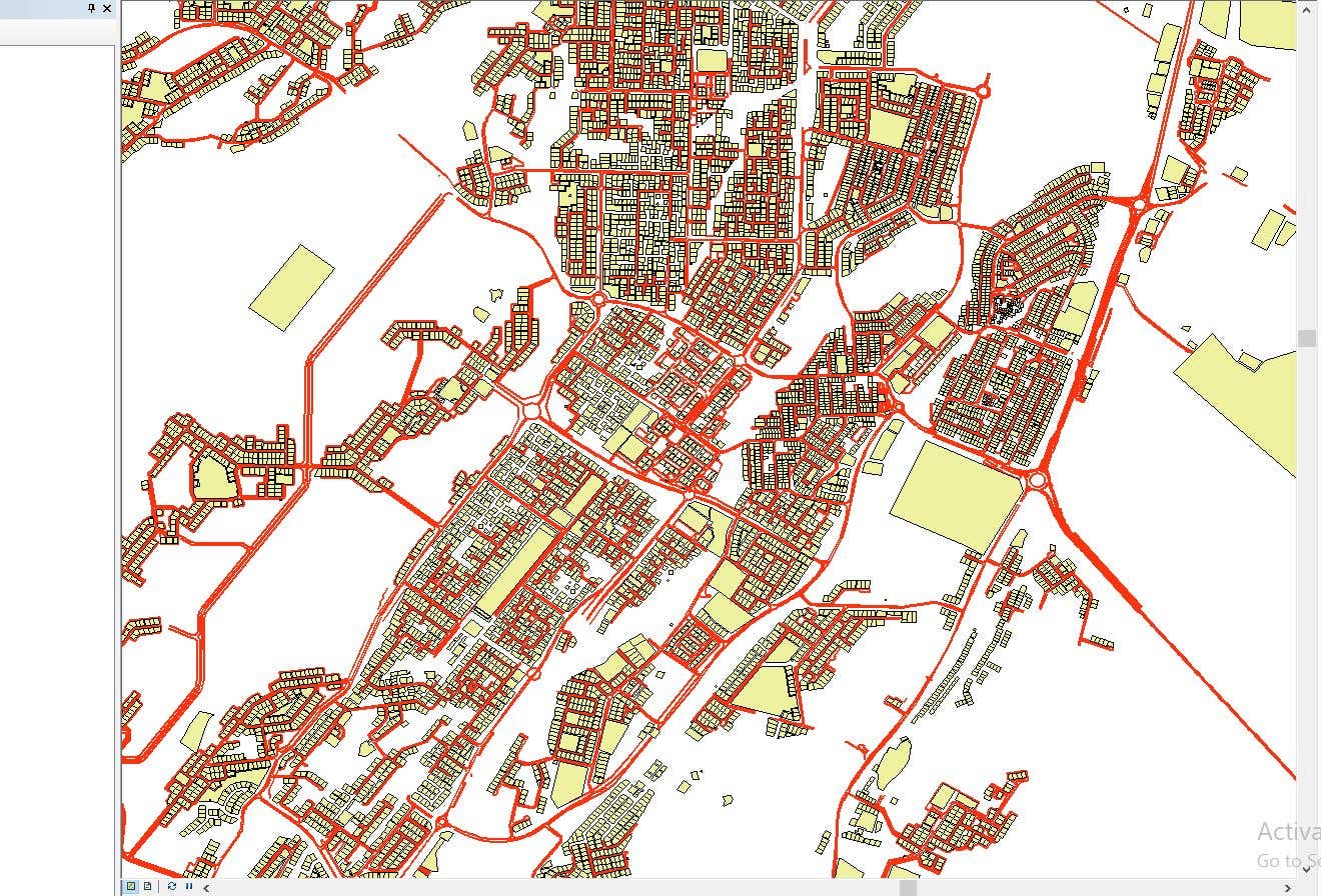

CAD to SHP Files

CAD to SHP Files
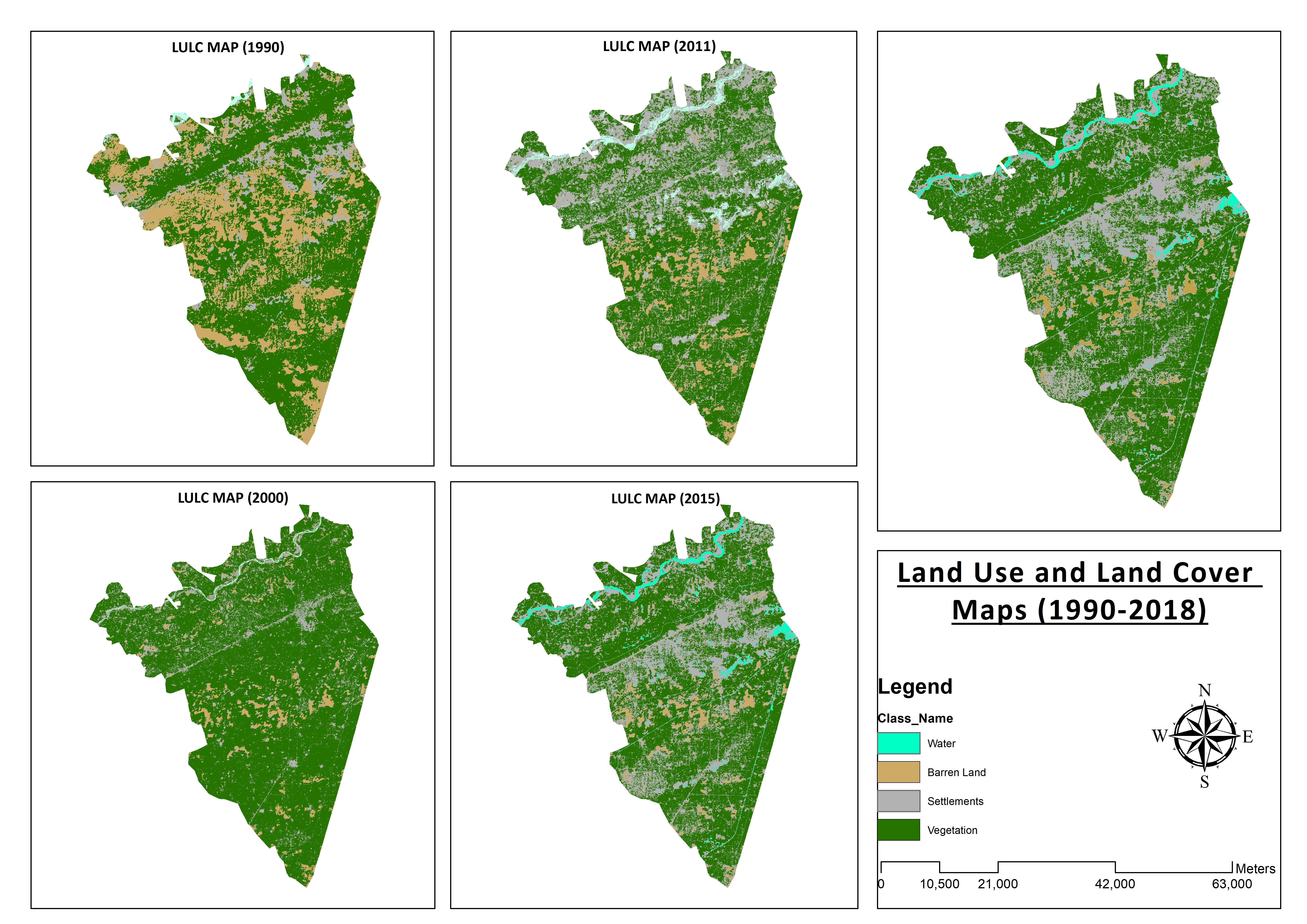

Land Use and Land Cover Maps
Preparation of Digital Elevation Model
Drone Mapping
Drone Mapping
Drone Mapping
CAD to SHP Files
CAD to SHP Files
Land Use and Land Cover Maps
Ocene
Spremembe shranjene
Tukaj ni nobenih ocen!
Izkušnje
Remote Sensing and GIS Analyst
sep. 2018 - okt. 2019 (1 leto, 1 mesec)
Developed, integrated and Implemented GIS and Geodesy based Topographic Survey Plans under different Hydro-Power Projects in Northern Pakistan, Extension of Canal Projects to increase its capacity in Sindh-Balochistan, Analysis of Suitable Site Selection for different development sites by using Drone for Aerial Mapping and their detailed pre-feasibility studies with different softwares, to analyse and interpret spatial data to produce interacting Maps and Reports while ensuring quality control.
Research Associate GIS
okt. 2015 - okt. 2018 (3 leta)
Deployed GIS-based system under Urban Immovable Property Tax (UIPT) for Punjab Excise & Taxation Department. Provided comprehensive support in creating the system while take advantage of software suites like ArcGIS Suite and ERDAS Imagine. Prepared communicating maps to help surveyors in Analyzing geo-spatial data to verify it during ground truthing. Created shapefiles to merge topographical data with external data through layering process.
Izobrazba
Master of Philosophy in Geographic Information System
(2 leti)
Bachelors in Geographic Information System
(4 leta)
Kvalifikacije
MS-Office
TEVTA
2017
MS-Office Certification in MS-Word, Excel and Power Point.
Publikacije
Analysis of Flood Damage Assessment through Different Satellite Datasets in Southern Punjab,Pakistan
International Journal of Innovations in Science & Technology
RS and GIS techniques can achieve the objectives and significant analyses through visual interpretations. These techniques are also used to identify the flood affected regions. The study site was examined by applying supervised classification determining that 16900.96 Hectors of agriculture land was damaged while Sparse Riverine Forest had the area 44.52 hectors. The damaged built-up area was 1805.78 Hectors.
Estimation of Net Rice Production by Remote Sensing and Multi Source Datasets
Sarhad Journal Of Agriculture
Estimation of net crop production before harvest enables agronomists and decision makers to determine the volume of grain precisely. Yield estimation is one of the challenging tasks which is significant to evaluate accurately for farmers. This research was conducted in eastern Punjab Pakistan by incorporating yield/area as reported by Crop Reporting Service Department along with open source satellite datasets.
Stopite v stik s/z Muneeb A. glede vašega dela
Prijavite se, da se o podrobnostih pogovorite v klepetu.
Verifikacije
Top spretnosti
Brskajte med podobnimi freelancerji
Brskajte med podobnimi izložbami
Vabilo uspešno poslano!
Hvala! Po e-pošti smo vam poslali povezavo za prevzem brezplačnega dobropisa.
Pri pošiljanju vašega e-sporočila je šlo nekaj narobe. Poskusite znova.
Kopiranje v odložišče ni uspelo, poskusite znova po spremembi vaših dovoljenj.
Skopirano v odložišče.
Nalaganje predogleda
Geolociranje je bilo dovoljeno.
Vaša prijavna seja je potekla, zato ste bili odjavljeni. Prosimo, da se znova prijavite.